


What is the problem?
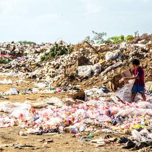
Mwanza is Tanzania’s second largest city and one of the fastest developing urban centers in sub-Saharan Africa. Official data from the city administration estimates that 357 tonnes of solid waste are produced by the city each day. The municipal waste management system is supported by four private companies who act as aggregators and five community-based waste collection services. However, the city faces numerous challenges that threaten to overwhelm the current waste management system including low investment, a lack of recycling facilities and the growth of informal settlements with unmapped waste management infrastructure.
What did the Accelerator Lab and partners do?
The Lab used satellite data and crowdmapping to create an overview of the production and collection of waste in Mwanza’s Buhongwa ward, a peripheral neighborhood with many informal settlements. They partnered with OpenMap Development Tanzania (OMDTZ), to run a virtual mapathon with ten local university students using the Humanitarian OpenStreetMap platform. Over multiple sessions in the space of two weeks, students labeled buildings, roads and waterways in the Buhongwa ward, as well as identifying possible trash sites. The resulting dataset was verified by the team at OMDTZ.
What was the benefit of using collective intelligence for this issue?
Through the virtual mapathons, the Lab generated a novel dataset about the core infrastructure of Buhongwa ward, mapping over 26,000 features such as roads, waterways, buildings and trash sites. The data has revealed the existence of new buildings that had previously not been registered by government officials. This information is being used by the city’s Urban Water Supply and Sanitation Authority to add waste collection points to serve the previously unmapped informal settlements.
What next?
The team has been using the OpenDataKit to enrich their data by mapping extra features like the location of waste dumpsites with local residents. Alongside this, they plan to collect qualitative insights about residents’ perceptions and behaviors towards waste through community meetings. This data will be integrated into the existing infrastructure map produced by the remote volunteers and will help to inform the city’s future waste management services.
What does this experience tell us about collective intelligence design?
Using the virtual mapathon approach and an existing platform for task allocation, the team were able to easily generate a large amount of novel data in the space of just one month, including labeling and validation. Mapathons or short duration ‘blitz’ methods are often used in participatory science to help fill data gaps. This can be a useful approach for collective intelligence projects that don’t have, or don’t need, long-term volunteer engagement.